There are treks you complete, and then there are treks that change you. The Rupin Pass Trek belongs firmly in the second category. Weaving through dense oak forests, cascading waterfalls frozen mid-flow, and a dramatic hanging valley that looks straight out of a fantasy novel, this trail in the Uttarakhand Himalayas has earned its place as one of India’s most visually rewarding high-altitude adventures.
With trail infrastructure improving, weather windows becoming more predictable, and the global trekking community increasingly drawn to authentic Himalayan experiences over overcrowded routes, 2026 is shaping up to be the most compelling year yet to lace up your boots and head for the hills. If you have been sitting on the fence about this one, this guide will give you every reason to commit.
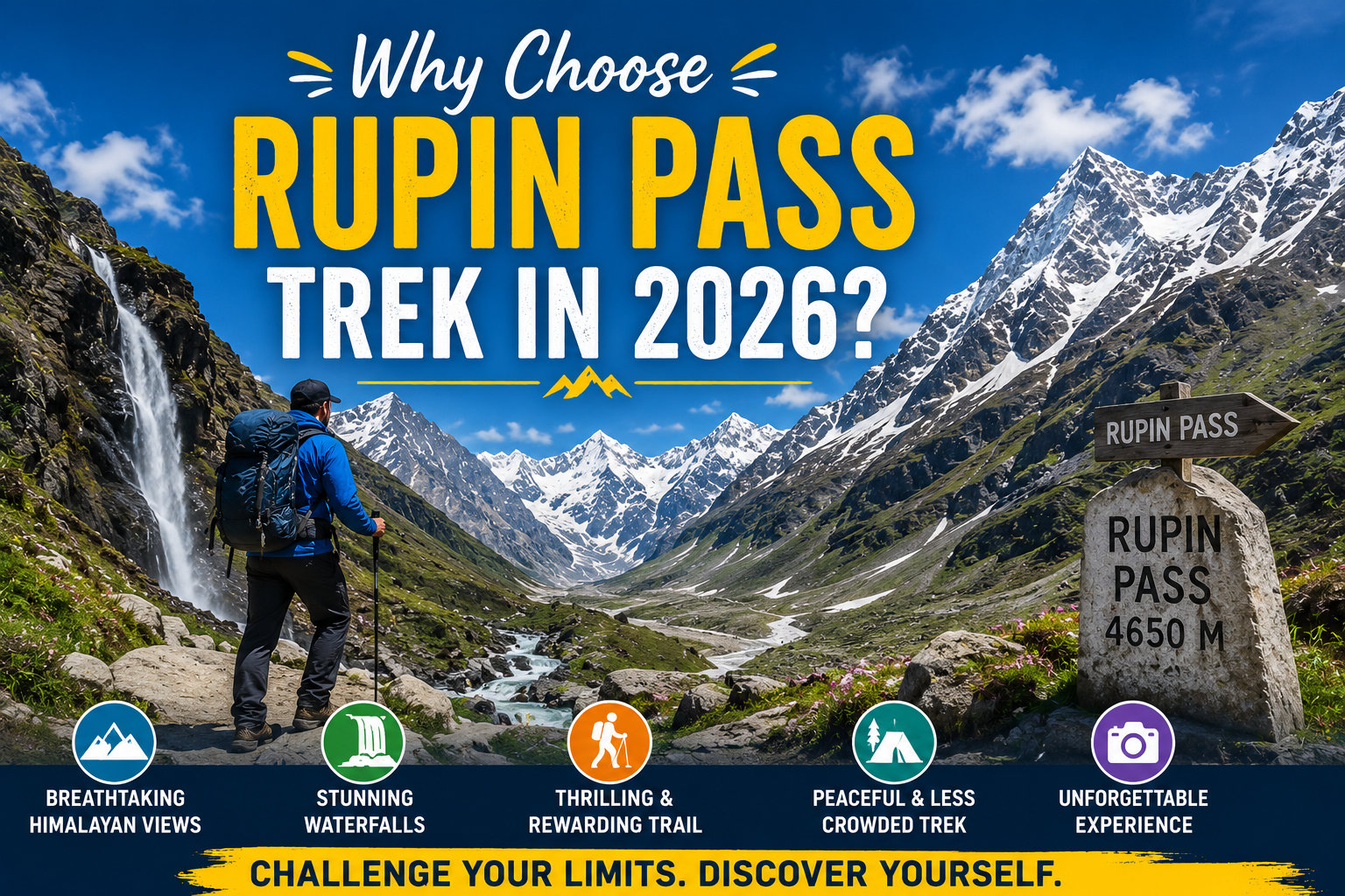
So, why choose Rupin Pass Trek in 2026? Because right now, it strikes the perfect balance between accessibility and raw wilderness, between challenge and reward. This article breaks down everything you need to know, from the trail highlights and ideal itinerary to permits, preparation, and what sets this trek apart from every other high-altitude route in the country.
The Rupin Pass Trek at a Glance
Before getting into the reasons, here is a quick overview for those new to the trail.
- Location: Uttarkashi district, Uttarakhand, crossing into Himachal Pradesh
- Altitude: 15,250 feet (4,650 metres) at the pass
- Duration: 8 to 9 days
- Difficulty: Moderate to Difficult
- Best Season: May to June and September to October
- Start Point: Dhaula village, Uttarakhand
- End Point: Sangla valley, Himachal Pradesh
The route is a cross-state traverse, which means you start in one state and finish in another. That geographic crossing adds a unique narrative quality to the journey that few other Indian treks can match.
What Makes the Rupin Pass Trek Genuinely Special
The Rupin Pass Trek stands out for its constantly changing landscapes, hanging villages, snow bridges, waterfalls, alpine meadows, and dramatic mountain views. Crossing from Uttarakhand to Himachal Pradesh, this trek offers a rare mix of adventure, natural beauty, and authentic Himalayan culture in one unforgettable journey.
Unmatched Landscape Variety in a Single Route
Most treks offer one dominant landscape type: a valley, a ridge line, a plateau. Rupin Pass offers all of them. Within eight days, trekkers move through dense pine and oak forests, open meadows blanketed with wildflowers in spring, a dramatic waterfall that forms the centrepiece of the mid-trail section, a wide hanging valley that feels completely otherworldly, and finally the snow-covered pass itself before descending into the starkly beautiful Sangla valley.
This variety is not accidental. The trail follows the Rupin River upstream before crossing into a different watershed entirely, which means the terrain changes completely as you gain altitude. The result is a trek that never feels repetitive.
The Famous Rupin Waterfall: A Mandatory Stop
One of the most photographed locations on any Indian trek, the Rupin Waterfall is a sight that stops even experienced trekkers in their tracks. During May and early June, the waterfall is partially frozen and draped in massive snow sheets, creating an almost surreal visual where blue glacial water cuts through white ice walls.
This section of the trail, between Lower Waterfall Camp and Upper Waterfall Camp, is the most technically interesting part of the entire route. Trekkers navigate through snow bridges, past hanging ice formations, and through narrow corridors between rock and snow. It requires care, but no technical climbing skills.
The Hanging Valley: One of India’s Most Iconic Camping Spots
Above the waterfall section lies the hanging valley, a wide glaciated plateau suspended high above the main valley below. Camping here, with views of snow peaks all around and absolute silence except for the wind, is the kind of experience that stays with a person for years.
The Rupin Pass Trek camping spots in this section rank among the finest anywhere in the Indian Himalayas. If you are a photographer or someone who simply values moments of genuine awe, this is where the trek delivers most powerfully.
Why 2026 is the Right Year to Do It
2026 is the perfect time to experience the Rupin Pass Trek as trekking infrastructure, safety arrangements, and guided expedition quality continue to improve. With rising interest in Himalayan adventures, completing Rupin Pass now offers a more raw, less commercialized experience while still enjoying better accessibility, organized camps, and expert trek support.
Trail Conditions and Infrastructure Are Improving
In recent years, the Rupin Pass Trek route has seen meaningful improvements in trail marking, basic amenities at key campsites, and rescue infrastructure. Local guide associations have become more organised, and the forest department has tightened its permit and waste management protocols.
The result is a trail that is safer and better managed without losing any of its wildness. You are not walking through a tourist corridor. The forests are still quiet, the villages still function as farming communities, and the locals you meet along the route still seem genuinely pleased to see visitors rather than fatigued by them.
Post-monsoon 2026 windows are looking particularly promising based on regional climate patterns, making September and October an excellent window for those wanting stable skies and golden-hour light on snow peaks.
Growing Global Interest in Himalayan Cross-State Treks
The trekking world has shifted. Overtourism at famous trails globally has pushed serious trekkers toward routes that offer challenge, beauty, and cultural depth without the crowding. Rupin Pass fits this profile almost perfectly.
It sits comfortably among the best treks in Uttarakhand, but it has not yet been swallowed up by mass tourism. Group sizes on the trail remain small, campsites feel spacious, and there are still days on the route where you might not see another trekking group at all. That is a rarity now in a world where even remote trails are filling up. Get here before that changes.
Ideal for Building High-Altitude Confidence
The elevation profile of Rupin Pass is well-designed for trekkers who want to push their limits without taking on a genuinely technical expedition. The highest point, the pass itself at 15,250 feet, is within reach for most reasonably fit adults with proper acclimatisation built into the itinerary.
The Rupin Pass Trek difficulty sits at the moderate-to-difficult level, which means it rewards preparation without requiring prior mountaineering experience. This makes it an ideal progression trek for anyone who has done routes like Kedarkantha or Brahmatal and wants to step up significantly.
Day-by-Day Overview of the Rupin Pass Trek Itinerary
Day 1: Dhaula to Sari (2,440 metres) A gentle opening day through farming villages and terraced fields. The trail follows the Rupin River and gives you your first real views of the valley walls ahead.
Day 2: Sari to Jiskun (2,680 metres) The forests deepen and the river grows louder. This day involves multiple stream crossings and takes you through some of the most beautiful oak and rhododendron woodland on the entire route.
Day 3: Jiskun to Lower Waterfall Camp (3,615 metres) Altitude gain begins in earnest. The Rupin Pass Trek altitude profile makes this day one of the most important for acclimatisation, and most operators build in rest time here.
Day 4: Lower Waterfall Camp to Upper Waterfall Camp (3,900 metres) The highlight of the trek for most trekkers. Snow travel begins here, and the famous waterfall section unfolds over several hours of careful walking.
Day 5: Upper Waterfall Camp to Rupin Pass Base Camp (4,500 metres) The hanging valley reveals itself fully on this day. Camp here is as close to a rooftop camp as most trekkers will ever experience.
Day 6: Base Camp to Rupin Pass (4,650 metres) and descent to Ronti Gad (3,800 metres) Summit day. An early alpine start, the crossing of the pass with panoramic views, and then a long descent into Himachal Pradesh. Physically demanding and emotionally memorable.
Day 7: Ronti Gad to Sangla (2,620 metres) The descent into Sangla valley is a full sensory shift. The landscape becomes drier, the villages different in character, and the air noticeably warmer. A fitting conclusion to the crossing.
How to Prepare for the Rupin Pass Trek in 2026
Prepare for the Rupin Pass Trek in 2026 with cardio training, strength workouts, proper gear, acclimatization planning, and mental readiness for high-altitude trekking.
Physical Fitness Requirements
The single most important thing you can do to improve your Rupin Pass experience is to arrive physically prepared. This is not a trail where you can expect to wing it. The combination of altitude, snow travel, long daily distances, and the steep ascent to the pass on summit day demands a genuine base of cardiovascular fitness.
A twelve-week preparation programme combining running or cycling with stair training and loaded hiking is the standard recommendation from most experienced guides. Building up to carrying a daypack of 8 to 10 kilograms over uneven terrain will closely simulate trail conditions.
Essential Gear and Packing
Gear selection on a snow trek can make or break your experience. The essentials go beyond standard hiking kit and include microspikes or crampons for the snow sections, trekking poles, a four-season sleeping bag rated to at least minus 10 degrees Celsius, and proper waterproof layering.
For a detailed breakdown of everything you need, refer to the Rupin Pass Trek Packing List 2026, which covers everything from technical layers and sun protection at altitude to campsite essentials and emergency kit. Getting this right before you leave the trailhead is far easier than improvising mid-route.
Permits and Regulations
All trekkers on the Rupin Pass route require a forest department permit. These can be arranged through registered trekking operators or directly at the forest checkpost at the trailhead. Additionally, carrying valid photo identification is mandatory, as there are checkposts at multiple points along the route.
Camping is permitted only at designated sites, and campfire restrictions are strictly enforced above the treeline. Waste management protocols require packing out all non-biodegradable waste, and most reputable operators now include this as a standard part of their service.
Rupin Pass Trek vs. Other Popular Himalayan Treks
How does Rupin Pass compare to other routes in the same category?
- Versus Kedarkantha: Kedarkantha is shorter, lower, and less technical. Rupin Pass is significantly more rewarding for those ready for the challenge.
- Versus Har Ki Dun: Har Ki Dun is a valley trek without a high pass crossing. Rupin Pass offers far more elevation drama and landscape diversity.
- Versus Pin Bhaba Pass: Similar in concept (a cross-state pass crossing), but Pin Bhaba is higher and more remote. Rupin Pass is more accessible and better supported.
- Versus Bali Pass: Both are considered among the finest pass treks in Uttarakhand. Rupin Pass has the edge in terms of visual highlights and route variety.
The honest conclusion is that for trekkers at the moderate-to-difficult level, Rupin Pass currently represents the best value in terms of experience per day on trail among all comparable Indian Himalayan routes.
Cultural Highlights Along the Route
The trail passes through a handful of small villages in the Uttarkashi district, and these communities add genuine human depth to the experience. The architecture is distinct, with wooden balconies and carved facades that reflect a blending of Garhwali and Kinnauri influences as you move closer to the Himachal border.
The people in villages like Dhaula, Sari, and Jiskun are predominantly farmers and herders. During spring treks, you will often see livestock being moved to higher pastures, and in autumn, the villages are busy with harvest. These rhythms of mountain life provide a context for the landscape that purely wilderness treks cannot offer.
Many trekking operators now offer village homestay options at the start of the route, which is one of the better ways to begin a trek. Waking up in a local home, eating a meal cooked on a wood-fired stove, and listening to someone describe the mountains you are about to walk through is a far richer start than checking into a roadside guesthouse.
Solo vs. Guided Trekking on Rupin Pass
This is a question that comes up frequently, and the honest answer is nuanced.
The trail is well-marked in its lower sections, but above the waterfall, route finding in snow requires experience. Without trail markings buried under snow, the high-altitude sections become genuinely difficult to navigate safely. For anyone without prior snow trekking experience, joining a guided group is strongly recommended.
Experienced trekkers with solid snow navigation skills and proper emergency kit can do the route independently, but should file a detailed route plan with local authorities, carry a personal locator beacon, and never attempt the pass crossing in deteriorating weather.
The Rupin Pass Trek guide services available through reputable operators in Dehradun and online are generally high quality in 2026, with many guides having done the route dozens of times. The local expertise they bring, particularly in reading snow conditions and weather windows, is invaluable.
Frequently Asked Questions
1. What is the best time to do the Rupin Pass Trek in 2026?
The two best windows are May to mid-June and mid-September to mid-October. The spring window offers the dramatic snow-waterfall spectacle, while autumn offers clearer skies, stable weather, and beautiful post-monsoon greenery at lower elevations.
2. How difficult is the Rupin Pass Trek?
It is rated moderate to difficult. Prior trekking experience and a good level of physical fitness are important. Snow sections above the waterfall require confidence on uneven terrain, and the summit day involves a long, steep ascent at high altitude.
3. Is the Rupin Pass Trek safe for beginners?
Not recommended as a first trek. Most trekkers who do Rupin Pass successfully have at least one or two previous Himalayan treks under their belt, such as Kedarkantha or Chopta Tungnath. Some fitness and acclimatisation experience makes a significant difference.
4. How do I get to the Dhaula trailhead?
Most trekkers fly into Dehradun and then take a combination of shared taxi or private vehicle via Nainbag and Mori to reach Dhaula. The drive takes approximately eight to ten hours depending on road conditions.
5. What permits are required?
A forest department permit is required, obtainable at the trailhead or through registered operators. Valid government-issued photo identification is mandatory throughout the route.
Summary
The Rupin Pass Trek is not just a walk in the mountains. It is a complete immersive experience that tests your body, quiets your mind, and rewards you with landscapes and memories that simply cannot be replicated anywhere else in the country.
We specialises in crafting Rupin Pass experiences that prioritise safety, sustainability, and genuine engagement with the mountains and the people who live in them. Whether you are looking for a fully guided group departure, a semi-guided private itinerary, or expert pre-trek planning support, we are here to help you get it right.
Choose Mountainiax, the best trekking agency in Uttarakhand, for expert guidance, safe routes, and unforgettable Himalayan adventures. Book your trek today and explore with confidence.