Uttarakhand’s got some of the gnarliest peaks in the Himalayas, and if you’re into mountaineering, this magical place is basically calling your name. It has got top tier views with adrenaline rushing ascents (they look unreal). It’s the whole deal with the grind, the altitude, the stories behind these mountains.
Here’s the lowdown on the top 10 highest peaks in the state, packed with what you need to know before you strap on your pack. Also, there’s a shoutout to Meru Peak and that insane Jimmy Chin flick that’ll make you want to climb something, anything, right now. Let’s get into it.
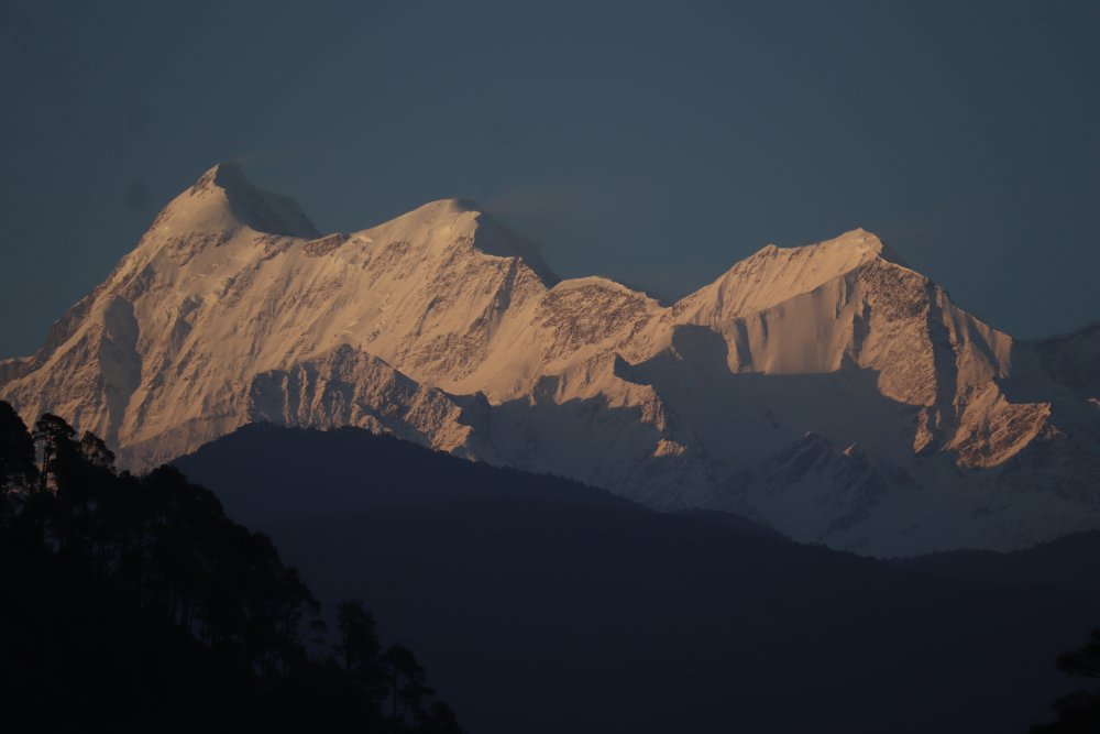
1. Nanda Devi – 7,816 m (25,643 ft)
Nanda Devi claims the top spot at 7,816 meters, making it Uttarakhand’s highest peak and India’s second tallest mountain. The massif of Nanda devi is divided into two, Nada Devi west and Nanda devi east. Located in Chamoli district within the Garhwal Himalayas, it’s surrounded by the Nanda Devi Sanctuary, a UNESCO World Heritage Site.
It’s named after a goddess symbolizing bliss, it carries a deep cultural resonance. Nanda devi is known to be the daughter of Himalayas and also patron goddess for many locals in the region. There is a three week long pilgrimage held in Uttarakhand every 12 years known as Nanda devi raj -jaat, the route of the yatra follows Karur Village to Nauti Village and goes upto Bedni Bugyal, Roopkund and Homkund, with mysterious four horned sheep leading it. After many unsuccessful attempts, the first successful ascent was done on 29 August 1936, thanks to Bill Tilman and Noel Odell. The detailed description of the Nanda devi peak was mentioned in the book of Bill Aitken, The Nanda devi Affair. The climbers face technical climbs, remote trails, and fickle weather, but the payoff is a view that feels almost sacred.
| Detail | Information |
| Height | 7,816 m (25,643 ft) |
| Location | Chamoli, Garhwal Himalayas |
| Access Point | Joshimath |
| Route | Via Nanda Devi National Park |
| Difficulty | Expert—requires technical climbing (rock/snow/ice) |
| Best Time | May to October |
| Highlights | UNESCO status, rich flora and fauna |
| Challenges | High altitude, tricky terrain, weather |
| Permits | Mandatory due to sanctuary restrictions |
2. Kamet – 7,756 m (25,446 ft)
Kamet sits close behind at 7,756 meters, also in Chamoli, near the Tibetan border. Its pyramid-like shape flattens at the summit, creating a distinctive profile. The peak is the second Highest mountain in the region of Uttarakhand and 29th highest in the world. The peak is surrounded by three primarily neighbouring peaks, Mukut Prabat, Abi Gamen and Mana Peak. Frank Smythe led the first team to conquer it in 1931, the British Expedition included team members Eric Shipton, R.L Holdsworth, Raymond Greene, Bill Birnie and Lawa Sherpa. The climb also uncovered the nearby UNSECO World heritage site, Valley of Flowers and Frank S Smythe wrote a book on this “Valley of flowers (1938)”. The approach to the summit involves the East Kamet route, ascending via Meade’s Col. The route involves steep gullies, glaciers and rock walls, demanding serious preparation and experience.
| Detail | Information |
| Height | 7,756 m (25,446 ft) |
| Location | Chamoli, near Tibet |
| Access Point | Joshimath to Niti Village |
| Route | Via East Kamet Glacier |
| Difficulty | Advanced—glacier skills needed |
| Best Time | May to September |
| Highlights | Remote setting, Valley of Flowers tie-in |
| Challenges | Glacial crossings, altitude exposure |
| Permits | Often required for border proximity |
3. Abi Gamin – 7,355 m (24,131 ft)
Abi Gamin rises to 7,355 meters, a formidable peak in the Garhwal Himalayas’ Zaskar Range, just 2 kilometers northeast of its towering neighbor, Kamet. The high altitude saddle, Meade’s col separated the peak from Kamet. Visible from Joshimath on clear days, it shares much of Kamet’s logistical backbone,same base camps, similar glacial approaches, but carves its own identity with steep, icy slopes that demand precision and grit.
First summited in 1950 by an Anglo Swiss Group including mountaineers Alfred Tissieres, R. Dittert and G. Chevalley and one Englishman Kenneth Berill , it’s often overshadowed by Kamet’s fame, yet it’s no less challenging or rewarding. The name “Abi Gamin” ties to a local term for ridge, fitting its sharp, elongated profile against the Himalayan skyline.
| Detail | Information |
| Height | 7,355 m (24,131 ft) |
| Location | Chamoli, near Kamet |
| Access Point | Joshimath |
| Route | Tied to Kamet expedition routes |
| Difficulty | Expert—icy, technical terrain |
| Best Time | May to October |
| Highlights | Scenic overlap with Kamet |
| Challenges | Steep ice, high-altitude conditions |
| Permits | Usually bundled with Kamet permits |
4. Mana Peak – 7,272 m (23,858 ft)
Mana Peak hits 7,272 meters near Badrinath in Chamoli, tied into the Kamet group. It’s right by this holy town, so there’s a spiritual vibe that mixes with the tough climb ahead. Frank Smythe’s crew first tackled it in 1937, coming off their Kamet win.
You start from Mana village known as India’s last stop before Tibet, and the trail’s a rugged haul, full of rocky patches and big altitude jumps. What makes it worth it? The killer views of the Alaknanda River valley stretching out below, especially when the light hits.
The path takes you close to Vasudhara Falls, a massive 400-foot drop that’s a cool side trip before things get serious. It’s not the tallest peak around, but that blend of hard climbing and a sacred backdrop gives it a special edge. You can even spot Badrinath’s temple from up high on a clear day, pretty neat for a mountain adventure.
| Detail | Information |
| Height | 7,272 m (23,858 ft) |
| Location | Chamoli, near Badrinath |
| Access Point | Mana Village |
| Route | Via Badrinath trails |
| Difficulty | Advanced—rocky, high-altitude |
| Best Time | May to October |
| Highlights | Spiritual backdrop, river views |
| Challenges | Altitude, remote access |
| Permits | Special Permits, sanctuary edges |
5. Mukut Parbat – 7,242 m (23,760 ft)
Mukut Parbat, at 7,242 meters, lives up to its “Crown Mountain” name in the Kamet group near Gangotri Glacier. A New Zealand team led by Earle Riddiford, Edmund Cotter, Pasang Dawa Sherpa climbed it in 1951, and it’s been a tough nut ever since.
You kick off from Joshimath, heading toward the Chaturangi Glacier, a wild, colorful stretch of ice that’s tricky to cross. The climb’s steep and technical, with some icy bits t hat’ll keep you on your toes, but once you’re up there, the views of Kamet and other peaks are unreal.
It’s not as famous as some neighbors, but that’s part of the charm. You get fewer people, more solitude. The Gangotri Glacier down below feeds into the Ganges, so you’re basically standing above a lifeline. Lots of people pair it with Kamet, though it’s got enough punch to stand alone if you’re up for the challenge.
| Detail | Information |
| Height | 7,242 m (23,760 ft) |
| Location | Chamoli, near Gangotri |
| Access Point | Joshimath |
| Route | Via Chaturangi Glacier |
| Difficulty | Expert—technical climbing |
| Best Time | May to September |
| Highlights | Glacier proximity, expansive vistas |
| Challenges | Steep slopes, glacial risks |
| Permits | Often required for glacier areas |
6. Hardeol – 7,151 m (23,461 ft)
Hardeol’s at 7,151 meters in Pithoragarh, part of the Kumaon Himalayas, sitting close to Nanda Devi Sanctuary’s eastern edge. An Indo-Tibetan Border Police team first hit the top in 1978, and getting there is no picnic. You start in Munsiyari, trekking through Milam Valley, once a busy trade route to Tibet, now pretty quiet. The Milam Glacier’s your next hurdle, a 16-km stretch that leads to steep slopes and spots where avalanches are a real worry.
The valley has old villages like Milam and Burfu, giving you a peek at life up here before the climb kicks in. It’s remote, tough, and wild, perfect if you like a challenge without a crowd. The views stretch toward Nanda Devi, making it a solid pick for anyone ready to push their limits.
| Detail | Information |
| Height | 7,151 m (23,461 ft) |
| Location | Pithoragarh, Kumaon Himalayas |
| Access Point | Munsiyari |
| Route | Via Milam Glacier |
| Difficulty | Advanced—remote, rugged |
| Best Time | May to October |
| Highlights | Milam Valley, sanctuary views |
| Challenges | Avalanches, isolation |
| Permits | Required for sanctuary proximity |
7. Chaukhamba I – 7,138 m (23,419 ft)
Chaukhamba I, at 7,138 meters, heads up the four-peaked Chaukhamba massif near Gangotri in the Garhwal Himalayas. The name “four pillars” fits its bold, blocky shape, and it’s been a draw since a French-Swiss team summited in 1952. You start from Joshimath, heading toward Mana, then onto the Gangotri Glacier, a massive ice flow that’s key to the climb. It’s got a mix of glacier travel and steep sections, so it’s a favorite for folks who love a varied challenge.
Being near Badrinath you can visit the temple on a good day, tying the trek to something bigger. The massif’s four peaks make it a standout in the skyline, and the glacier views are hard to beat. It’s a solid pick if you’re into big mountains with a bit of history.
| Detail | Information |
| Height | 7,138 m (23,419 ft) |
| Location | Chamoli, near Gangotri |
| Access Point | Joshimath to Mana |
| Route | Via Gangotri Glacier |
| Difficulty | Expert—glacier navigation |
| Best Time | May to October |
| Highlights | Four peaks, glacier scenery |
| Challenges | High altitude, technical sections |
| Permits | May be required for restricted zones |
8. Trisul I – 7,120 m (23,360 ft)
Trisul I’s at 7,120 meters, stretching across Bageshwar and Chamoli in the Kumaon Himalayas. Named after Shiva’s trident, it’s a three-peaked massif that made history when Tom Longstaff climbed it in 1907, the first 7,000-meter peak ever summited. You start from Chandaniya Ghat, and it’s a moderate-to-tough trek with a long ridge that’s got some bite. You can spot it from Kausani or Roopkund, where it looms over that spooky skeleton lake.
The climb isn’t as technical as some, but the distance and altitude still pack a punch. It’s got a popular legacy, and the views from up top tie into the whole trident theme, three peaks lined up like a divine marker. A great one if you want history with your hike.
| Detail | Information |
| Height | 7,120 m (23,360 ft) |
| Location | Bageshwar/Chamoli, Kumaon |
| Access Point | Chandaniya Ghat |
| Route | Via Roopkund trek for views |
| Difficulty | Moderate to advanced—long ridge |
| Best Time | May to October |
| Highlights | Trident shape, historic climb |
| Challenges | Lengthy approach, altitude |
| Permits | Special Permits |
9. Tirsuli I – 7,074 m (23,209 ft)
Tirsuli I reaches 7,074 meters in the Zaskar Range, crossing Pithoragarh and Chamoli. It’s tied to Nanda Devi Sanctuary’s eastern edge and got its first summit in 1966 by an Indian team. The trek starts in Munsiyari, heading through Milam Valley, a steep, remote slog with a dark past from a 1939 Polish expedition that ended in tragedy. It’s not as crowded as other peaks, but the climb is just as tough, with sharp drops and lonely trails.
The Milam Glacier sets the climbs, and the views toward Nanda Devi are a big draw. It’s a quieter option for adventurers who don’t mind the isolation and want a piece of Kumaon’s wild side.
| Detail | Information |
| Height | 7,074 m (23,209 ft) |
| Location | Pithoragarh/Chamoli, Zaskar Range |
| Access Point | Munsiyari |
| Route | Via Milam Valley |
| Difficulty | Advanced—steep, isolated |
| Best Time | May to October |
| Highlights | Sanctuary views, climbing history |
| Challenges | Remote trails, steep drops |
| Permits | Often needed for sanctuary areas |
10. Changabang – 6,864 m (22,520 ft)
Changabang’s at 6,864 meters in Chamoli, part of the Garhwal Himalayas, and it’s the northeast wall of Nanda Devi Sanctuary. A British team first climbed it in 1974, and it’s all about technical rock: steep, jagged, and raw. You start from Joshimath, linking up with Nanda Devi trails, and it’s a favorite for folks who love a real climbing challenge over pure height.
The rocky face is what sets it apart, with a rep for being tough as nails. The views into the sanctuary are a bonus, and it’s got that untamed feel that pulls in serious trekkers looking for something different.
| Detail | Information |
| Height | 6,864 m (22,520 ft) |
| Location | Chamoli, Garhwal Himalayas |
| Access Point | Joshimath |
| Route | Via Nanda Devi trails |
| Difficulty | Expert—rock climbing skills |
| Best Time | May to October |
| Highlights | Steep profile, sanctuary wall |
| Challenges | Technical rock, high exposure |
| Permits | May be required for sanctuary access |
Spotlight: Meru Peak and Jimmy Chin’s Documentary
Meru Peak, at 6,660 meters (21,850 ft), doesn’t crack the top 10 height-wise, but it’s a legend in its own right. Located in Uttarakhand’s Gangotri region, its Shark’s Fin route, a near-vertical granite wall, has long been a climber’s obsession.
Jimmy Chin, alongside Conrad Anker and Renan Ozturk, took it on, and their 2015 documentary Meru captures the saga. After years of setbacks: avalanches, frostbite, brutal conditions, they summited in 2011 over 19 grueling days. The film, which snagged Sundance’s Audience Award, blends raw footage with real emotion, showing what it takes to conquer the unconquerable. It’s a must-see for anyone eyeing these peaks.
Meru Peak Essentials
| Detail | Information |
| Height | 6,660 m (21,850 ft) |
| Location | Gangotri, Garhwal Himalayas |
| Access Point | Gangotri |
| Route | Shark’s Fin |
| Difficulty | Extreme—technical rock and ice |
| Best Time | May to October |
| Highlights | Iconic climb, documentary fame |
| Challenges | Vertical wall, severe weather |
| Permits | Required for expedition |
Notable Climbing Records
Uttarakhand’s peaks have etched their names in mountaineering history:
- Trisul I (1907): Tom Longstaff’s ascent marked the first 7,000-meter climb worldwide, a feat using basic gear.
- Nanda Devi (1936): Tilman and Odell’s summit ended a 30-year quest, navigating the sanctuary’s defenses.
- Kamet (1931): Smythe’s pre-WWII record stood as India’s highest until the 1950s.
- Meru (2011): Chin’s team conquered the Shark’s Fin after three attempts, a modern triumph.
Geographical Highlights
- Nanda Devi Sanctuary: A 630 sq km basin with snow leopards and Himalayan monals, closed 1983-2003 for conservation.
- Gangotri Glacier: Feeds Chaukhamba and Mukut Parbat, one of India’s largest at 30 km long.
- Milam Glacier: Stretches 16 km, linking Hardeol and Tirsuli I, a Kumaon lifeline.
- Zaskar Range: Hosts Abi Gamin and Tirsuli I, a rugged spine near Tibet.
Trekking Logistics
Planning a trip? Here’s the rundown:
- Base Towns: Joshimath (Garhwal peaks), Munsiyari (Kumaon peaks), and Gangotri (Meru) are key hubs with gear shops and guides.
- Permits: Nanda Devi, Hardeol, and border peaks like Kamet need Inner Line Permits.Apply via local authorities or trekking agencies.
- Travel: Delhi to Dehradun (flight or train), then buses or taxis to base towns (8-12 hours).
- Costs: Expect $500-$1500 per trip, covering permits, guides, and gear rentals.
Safety and Preparation Tips
- Acclimatization: Spend 2-3 days at 3,000-4,000 meters before climbing.
- Gear: Crampons, ice axes, and ropes are musts for glaciers, layer up for -20°C nights.
- Weather: Monsoons (July-August) bring landslides. Stick to May-June or September-October.
- Health: Carry Diamox for altitude sickness, and train for 4,000+ meter gains over 5-10 days.
Why Uttarakhand’s Peaks Matter
These mountains are benchmarks of endurance and beauty. Nanda Devi’s sanctuary teams with snow leopards and Himalayan monals. Kamet’s climb ties into the Valley of Flowers discovery. Trisul’s trident looms over Roopkund’s eerie skeletal lake.
Each peak offers something different, whether it’s a physical test, a cultural connection, or a story etched in history. For trekkers, the season peaks from May to October, though permits and weather checks are non-negotiable. Start planning. Uttarakhand’s heights are waiting.
With the Panch Kedar Yatra season approaching, it’s time to plan something extraordinary. From breathtaking peaks to spiritually charged temples hidden deep in the Himalayas, this journey offers an experience that feels almost unreal. If you’re searching for adventure with meaning, this is where your story begins.
Visit this page for Trek Packages, Itinerary & Booking