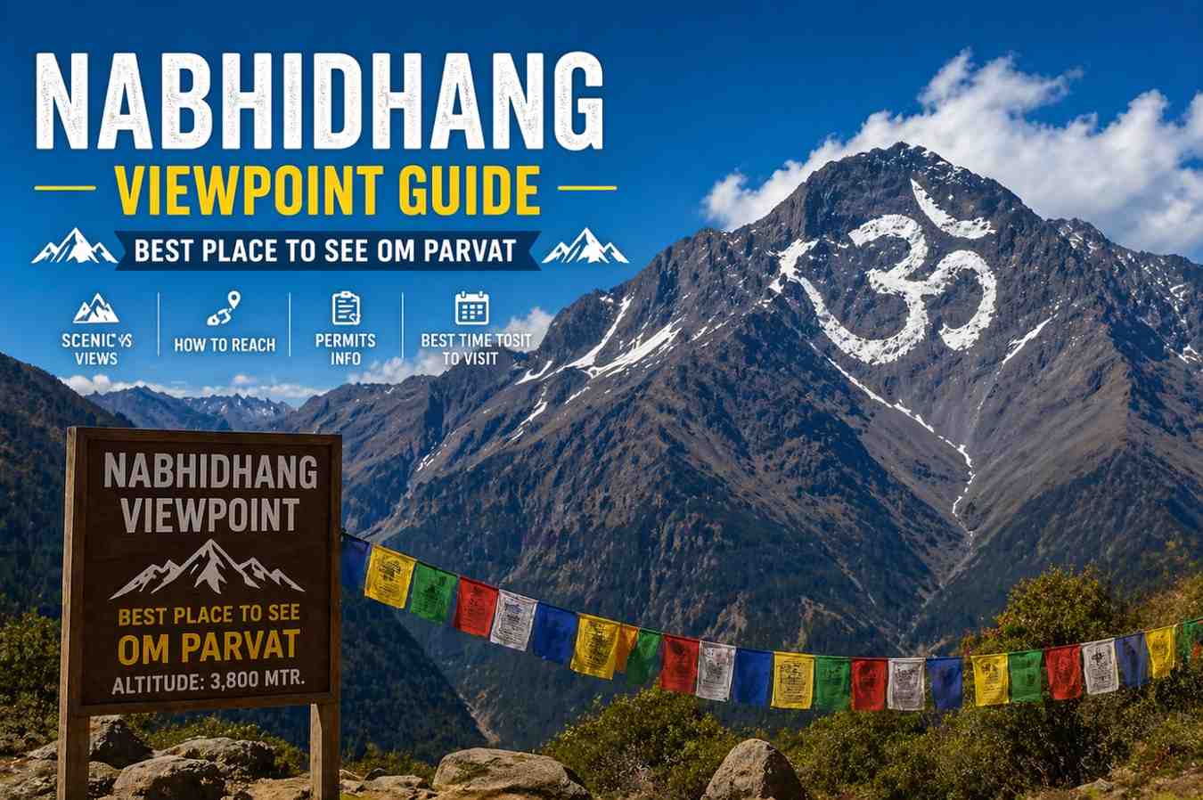
There are viewpoints across the Himalayas that reward the effort of reaching them with a decent panorama. And then there is Nabhidhang. At 4,266 metres above sea level in the remote Byans Valley of Uttarakhand, Nabhidhang occupies an entirely different category. This is the single best vantage point in the world to witness the naturally occurring OM symbol on Om Parvat, a sacred snowfield formation on a 6,191-metre peak that has drawn Hindu pilgrims, Himalayan trekkers, and curious travellers for generations.
What makes Nabhidhang remarkable is not just what you see from it, but what the act of standing there asks of you. The route demands physical preparation, proper permits, and genuine respect for the altitude. Most people who reach Nabhidhang describe the experience as one of the most spiritually charged moments of their lives, regardless of religious background. The sight of the naturally formed OM etched in permanent snow on the dark face of the mountain is, quite simply, unlike anything else in the Himalayan world.
This complete Nabhidhang Viewpoint Guide is written to answer every question serious pilgrims and trekkers ask before making this journey. From the route out of Gunji Village to the precise photography windows, from what the OM looks like across different seasons to how weather can make or break your darshan, everything you need to plan intelligently is here.
What Is Nabhidhang and Why Does It Matter
Nabhidhang is a high-altitude meadow and viewpoint located at approximately 4,266 metres in the Pithoragarh district of Uttarakhand. It sits at the edge of a ridge that opens up a direct, unobstructed sightline to Om Parvat, a sacred Himalayan peak where permanent snow forms a natural pattern closely resembling the Sanskrit symbol for OM.
The significance of this location stretches back centuries. Ancient texts and local oral traditions reference this corridor as part of the original Kailash Mansarovar pilgrimage route. The Om Parvat darshan at Nabhidhang became more widely known among modern pilgrims after organized yatra circuits were established through KMVN and private operators. Today, it is one of the most anticipated moments on the entire Adi Kailash Yatra circuit.
What sets Nabhidhang apart from other Om Parvat viewpoints is geometry and proximity. The viewpoint is positioned such that the natural OM snowfield on the mountain’s southwest face is visible in near-perfect alignment. On clear days, the symbol is crisp, large, and unmistakable. Even those unfamiliar with Sanskrit immediately recognize the shape without prompting.
The Route to Nabhidhang: From Gunji via Kalapani
The standard route to Nabhidhang begins at Gunji Village (3,200 metres), the operational base camp of the Adi Kailash Yatra and the last major settlement before the high passes. From Gunji, the path moves northeast through some of the most striking landscapes in the Kumaon Himalayas.
Gunji to Kalapani
Distance: Approximately 10 kilometres Elevation gain: From 3,200 metres to approximately 3,600 metres Time: 3 to 4 hours on foot, or accessible by vehicle on the road that parallels the trail
Kalapani is a historically significant location where the Kali River originates and where an ancient Kali temple stands. The name Kalapani carries deep meaning, both in terms of its religious importance and the geopolitical sensitivity of the region, which lies near the India-Nepal-China trijunction. ITBP personnel maintain a visible presence here and all pilgrims must have valid Inner Line Permits.
The walk from Gunji to Kalapani is relatively moderate compared to what follows. The trail follows the river valley, climbing gradually through alpine terrain. The air is noticeably thinner than Gunji, and the surrounding peaks grow more imposing with every kilometre.
Kalapani to Nabhidhang
Distance: Approximately 6 kilometres Elevation gain: From approximately 3,600 metres to 4,266 metres Time: 2.5 to 4 hours, depending on fitness and acclimatization status.
This is the demanding section. The trail climbs steeply from the Kalapani area onto a higher ridge system. The path is rocky and exposed in sections. Altitude effects become pronounced above 4,000 metres, and the pace naturally slows. Prayer flags, cairns, and the occasional ITBP marker guide the route.
The total journey from Gunji to Nabhidhang is approximately 16 kilometres with a total elevation gain of around 1,066 metres. Most yatra itineraries allow a full day for this trek, starting early from Gunji to reach Nabhidhang by midday when skies are typically at their clearest.
Practical route tips:
- Start no later than 5:30 AM from Gunji. Early starts are essential for clear darshan windows.
- Carry at least two litres of water and refill where possible, as streams at this altitude are generally clean.
- The trail is well-used during yatra season, and markers are present, but fog can disorient quickly above 3,800 metres.
- Mules are available from Gunji for those who prefer not to walk the full distance.
- Trekking poles are strongly recommended from Kalapani onward.
What to Expect on the Trek: Terrain, Altitude, and Conditions
The approach to Nabhidhang passes through three distinct ecological zones, each with its own character. Below Kalapani, the valley is relatively green, with small shrubs, alpine grasses, and seasonal wildflowers during June and July. Between Kalapani and the final climb, the landscape becomes increasingly rocky and bare. Above 4,000 metres, vegetation thins dramatically and the world takes on the austere, stripped quality that defines extreme high altitude.
Weather patterns on this route are highly variable. Mornings are typically the most stable period. By early afternoon, cloud systems frequently build over the peaks, and by mid-afternoon, the view of Om Parvat can be partially or completely obscured. This is why experienced guides always emphasize early departure.
Temperatures at Nabhidhang, even during peak season (June to September), can drop to near zero at night. During the day, the sun at this altitude is intense, and UV levels are extreme. Sunburn and snow blindness are real risks that many first-timers underestimate.
For those exploring What to Expect on Your First Adi Kailash Yatra, the Nabhidhang stretch represents the most physically demanding portion of the standard circuit. Arriving mentally prepared for the altitude and the gradient makes the experience dramatically more enjoyable.
The Om Symbol on Om Parvat: What You Are Actually Seeing
Understanding what you are looking for before you arrive at the Nabhidhang viewpoint deepens the experience significantly.
Om Parvat (also spelled Aum Parvat) is a 6,191-metre peak in the Kumaon Himalaya. Its southwest face contains a configuration of snowfields, rock ridges, and shadowed gullies that together form a pattern strikingly resembling the sacred Sanskrit symbol OM (the three curved lines and the crescent with a dot). Unlike human-made religious structures, this formation is entirely natural.
How the OM Symbol Appears Across Seasons
The visibility and definition of the OM symbol change meaningfully depending on when you visit.
Early June (post-snowmelt onset): The entire face of Om Parvat is typically still heavily snow-covered. The OM symbol may be partially obscured because the snowfield is too uniform. The contrast between snow and rock that defines the symbol is reduced.
Late June to July: As lower snowfields begin to melt, the darker rock surfaces emerge more clearly. The contrast between snow (forming the OM shape) and exposed rock (forming the negative space) sharpens. This is often considered the best period for clear, defined visibility of the symbol.
August: Monsoon moisture frequently brings cloud cover. Darshan can be intermittent. When clear windows occur, the symbol is well-defined, but guaranteed views are less reliable.
September: Post-monsoon clarity returns. Skies become the intense, washed blue of high-altitude autumn. The symbol is usually sharply visible and the surrounding peaks are free of haze. This is the preferred month for serious photographers.
October (late season): Early snowfall begins to fill in the definition once more. The symbol remains visible but less sharply contrasted. Very cold nights make camping at this altitude challenging.
Clear Day vs Cloudy Darshan
This distinction matters enormously and is a source of both joy and disappointment for yatris, depending on conditions.
On a clear day, the OM symbol on Om Parvat is visible from the Nabhidhang viewpoint as a precise, three-dimensional image. The snowfield catches the morning light from the southeast, and the shadows cast by the curved ridgelines that define the symbol deepen its legibility. Experienced trekkers describe it as looking painted, as though the mountain itself is displaying sacred calligraphy.
On a cloudy day, the peak may be partially or completely obscured. Pilgrims who have walked 16 kilometres at high altitude to reach the viewpoint and encounter cloud cover describe the experience as deeply humbling rather than disappointing. The practice of waiting, of sitting in silence for a clear window to open, has its own spiritual quality. Some yatris wait two to three hours and are eventually rewarded. Others are not. Both experiences are considered valid within the spiritual framework of the yatra.
The practical takeaway: build at least one contingency morning into your Nabhidhang schedule. If accommodation permits, staying a night at or near the viewpoint and attempting darshan at both sunrise and morning allows for a second chance if clouds dominate one session.
Accommodation Near Nabhidhang
Accommodation options at Nabhidhang itself are extremely limited. The following arrangements are the realistic choices for overnight stays:
KMVN or ITBP facilitated camps: During yatra season, temporary camping facilities are sometimes arranged in coordination with organized yatra operators. These are basic tent setups with sleeping mats and minimal provisions.
Return to Kalapani or Gunji: Many yatra itineraries do not overnight at Nabhidhang. Pilgrims reach the viewpoint on a day trek from Gunji or Kalapani and return to those lower settlements for accommodation. This is the most common approach on standard yatra packages.
Wild camping with permits: Experienced Himalayan trekkers with appropriate permits, cold-weather gear, and prior experience at altitude sometimes camp independently near Nabhidhang. This requires detailed preparation and is not recommended for first-time visitors to this region.
The Final Stop Before Adi Kailash on most organized routes is Nabhidhang, and the return journey brings pilgrims back through Kalapani and Gunji before proceeding toward the Adi Kailash base area. Planning your nights carefully around this sequence is essential.
Photography at the Nabhidhang Viewpoint
For mountain photographers, Nabhidhang is exceptional. Here is a focused breakdown of the photography opportunity.
Best time of day: Sunrise to approximately 10 AM. The low-angle morning light from the southeast illuminates the southwest face of Om Parvat directly, emphasizing the relief and shadow definition of the OM snowfield. By late morning, the light becomes flatter, and by early afternoon, cloud build-up often reduces visibility.
Recommended focal lengths: A telephoto lens in the 200mm to 400mm range on a full-frame equivalent system renders Om Parvat as a large, detailed subject. The peak is roughly 8 to 10 kilometres from the viewpoint as the crow flies. Wide-angle shots incorporating the foreground meadow, prayer flags, and the mountain in context are equally powerful.
Camera settings at altitude: UV intensity at 4,266 metres is extreme. A polarising filter will cut haze and enhance sky contrast dramatically. Protect camera batteries in an inner pocket, as cold temperatures drain lithium cells quickly.
Composition suggestions: The Nabhidhang meadow itself provides strong foreground material. Prayer flags are usually present along the ridge and add cultural context and colour. Early morning light and prayer flags, together with Om Parvat in the background, produce the images that define this location in visual terms.
Permits and Regulations at Nabhidhang
Reaching Nabhidhang falls within a restricted zone that requires specific documentation.
Inner Line Permit (ILP): Mandatory for all Indian nationals travelling beyond Dharchula into the Byans Valley. Obtainable from the District Magistrate’s office in Pithoragarh or through authorized yatra operators. For 2026, the permit application process through KMVN has been streamlined but still requires advance planning.
Foreign nationals: The region near Nabhidhang falls within a sensitive border zone. Foreign nationals currently face significant restrictions and should consult the current KMVN and Ministry of Home Affairs guidelines specific to the 2026 season before making any arrangements.
ITBP registration: On reaching Kalapani and Nabhidhang, your permits will be verified by ITBP personnel. Carry physical copies as well as digital backups.
For those considering the Adi Kailash Yatra by Helicopter 2026, permit requirements remain identical. Helicopter access does not bypass the Inner Line Permit requirement. All yatris, regardless of transport mode, must hold valid documentation.
Nabhidhang vs Other Om Parvat Viewing Points
Several locations along the Adi Kailash route offer views of Om Parvat. Understanding the difference helps you set realistic expectations.
Nabhidhang (4,266 metres): The definitive viewpoint. Direct line of sight to the southwest face. The OM symbol is fully legible on clear days. This is the gold standard.
Om Parvat route intermediate viewpoints: Lower-elevation glimpses of the peak are possible from parts of the Kalapani area, but at reduced clarity and with more intervening terrain.
Roadside viewpoints from the Dharchula-Gunji road: In exceptionally clear atmospheric conditions, distant views of Om Parvat are sometimes reported from parts of the access road, but these are incidental and unreliable for the specific OM symbol visibility.
The conclusion is straightforward: if seeing the Om symbol on Om Parvat clearly is your primary objective, Nabhidhang is the only viewpoint that consistently delivers that experience on clear days.
FAQs: Nabhidhang Viewpoint and Om Parvat
1. What is the altitude of Nabhidhang?
Nabhidhang is located at approximately 4,266 metres (13,996 feet) above sea level in the Pithoragarh district of Uttarakhand.
2. How far is Nabhidhang from Gunji?
The distance from Gunji to Nabhidhang via Kalapani is approximately 16 kilometres. The trek takes between 5 and 7 hours, depending on pace and acclimatization.
3. What is the best month to visit Nabhidhang for a clear Om Parvat view?
Late June to July and September are generally considered the best months for clear visibility of the OM symbol. September offers the advantage of post-monsoon clarity and stable skies.
4. Can I see the Om symbol on Om Parvat with the naked eye from Nabhidhang?
Yes. On a clear day, the OM symbol is visible to the naked eye from the Nabhidhang viewpoint. Binoculars or a telephoto camera lens significantly enhance the detail and definition.
5. Is Nabhidhang accessible by vehicle?
No. Nabhidhang is accessible only on foot from the Kalapani area or with the assistance of mules. There is no motorable road to the viewpoint itself.
Summary
The Nabhidhang Viewpoint Guide is built on one central truth: this is the most direct, clear, and powerful place in the world to witness the natural OM symbol on Om Parvat, and reaching it requires intelligent preparation rather than just physical effort. From understanding the route from Gunji via Kalapani to knowing which month gives the sharpest darshan, from reading the morning light for photography to accepting the spiritual lesson of a cloudy day, Nabhidhang rewards those who approach it with knowledge and humility in equal measure.
The Himalayas have never made their most profound gifts easy to access. Nabhidhang is no different. But for those who do the work, stand on that windswept ridge at 4,266 metres, and look up to find the OM carved in eternal snow on the face of the mountain, the experience belongs to a category of moments that no itinerary can fully prepare you for.
With the Adi Kailash Yatra season approaching, it’s time to plan a journey that blends spirituality with raw Himalayan adventure. From sacred lakes to the divine presence of Adi Kailash, every moment feels profound and transformative. If you seek purpose beyond travel, this is your path.
Visit this page for Yatra Packages, Itinerary & Booking.