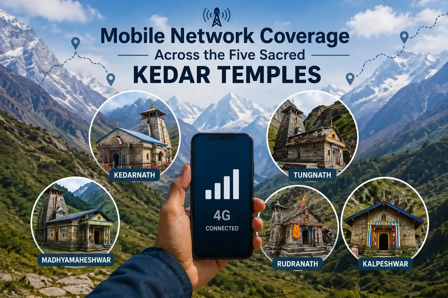
The Panch Kedar trail winds through some of the most remote and spiritually revered landscapes in the Garhwal Himalayas. Trekkers and pilgrims from across India and the world set out on this sacred circuit to seek the blessings of Lord Shiva across five ancient temples — Kedarnath, Tungnath, Rudranath, Madhyamaheshwar, and Kalpeshwar. But while the soul may find peace in these high-altitude sanctums, your smartphone might struggle considerably.
One of the most practical questions every trekker asks before beginning this journey is whether they can stay connected with their families, navigate using digital maps, and access emergency services along the way. Understanding Mobile Network Coverage Across the Five Sacred Kedar Temples is not just a matter of convenience — it is a genuine safety concern that every trekker must address before departure.
This detailed guide covers the ground-level network reality at each of the five shrines, explains which telecom operators perform best in different zones, and provides actionable communication tips so you can plan your yatra with full awareness and zero surprises.
Why Network Coverage is Challenging on the Panch Kedar Circuit
The geography of the Panch Kedar route is the primary reason mobile connectivity remains inconsistent. The trail crosses altitudes ranging from approximately 1,800 metres at Kalpeshwar to over 3,580 metres at Kedarnath. Dense forests, deep gorges, high ridgelines, and remote river valleys create natural barriers that significantly weaken signal transmission.
Telecom infrastructure in these regions is limited because the cost and logistics of installing and maintaining towers at such elevations are immense. The Indian government and BSNL have made efforts over the years to extend coverage to pilgrimage zones, particularly following the 2013 Kedarnath disaster, but large stretches of the trail still fall into dead zones.
Weather also plays a significant role. During the monsoon season (July to August), heavy cloud cover, rain, and fog further degrade signal quality even in areas where towers exist. Trekkers heading to Rudranath and Madhyamaheshwar — the most remote of the five shrines — should mentally and practically prepare for extended periods without any mobile signal.
Telecom Operators on the Panch Kedar Trail: Who Performs Best?
Understanding which SIM card for Panch Kedar trek to carry is the single most important connectivity decision you will make before starting your journey.
BSNL (Bharat Sanchar Nigam Limited)
BSNL remains the most reliable telecom network for Himalayan treks across Uttarakhand, and the Panch Kedar circuit is no exception. Being a government-owned operator, BSNL has historically invested in tower infrastructure in remote pilgrimage zones where private operators find it economically unviable. Trekkers consistently report BSNL offering voice call connectivity at Kedarnath temple, certain stretches near Kalpeshwar, and at some lower-altitude villages along the Tungnath route.
If you do not already have a BSNL SIM, it is strongly advisable to purchase one before starting your trek. Even a basic prepaid BSNL connection can be the difference between reaching emergency services and being completely cut off.
Reliance Jio
Jio has significantly expanded its 4G network coverage in Uttarakhand over the last few years, including deploying additional infrastructure near high-footfall pilgrimage zones. Near the Kedarnath base camp and the temple area, Jio users often report limited 4G or 3G data connectivity, especially during the early weeks of the pilgrimage season before network congestion sets in.
However, Jio signals drop sharply once you move beyond the main temple zones and into the remote trekking corridors leading to Rudranath and Madhyamaheshwar. Treat Jio as a secondary SIM card for the circuit, useful near Kedarnath and Kalpeshwar but unreliable in the deeper wilderness sections.
Airtel
Airtel performs reasonably well in base towns such as Ukhimath, Rudraprayag, Joshimath, and Chamoli — all of which serve as road-head gateways to the Panch Kedar temples. But as with Jio, Airtel coverage diminishes rapidly at higher altitudes and along the more remote trekking stretches. Airtel is not a recommended primary network for this circuit, though having it active is useful for connectivity at transit towns before and after your trek.
Vodafone-Idea (Vi)
Vi has the most limited presence among major operators on the Panch Kedar route. While it may function in towns like Rishikesh, Haridwar, and Dehradun during your journey to the trailhead, Vi users should not rely on it once the trek begins. Carrying a Vi-only SIM for this circuit is not advisable.
Network Coverage at Each of the Five Kedar Shrines
Mobile network connectivity across the Panch Kedar route varies significantly. Kedarnath usually has limited but available signals, while Tungnath, Rudranath, Madhyamaheshwar, and Kalpeshwar experience weak or intermittent coverage. Trekkers should prepare for offline navigation, limited internet access, and communication gaps during remote trekking sections.
Kedarnath (3,583 metres)
Kedarnath is the most visited and best-connected of the five shrines. Both BSNL and Jio have invested in improving connectivity here, and trekkers frequently report receiving BSNL signal at Kedarnath for voice calls. Jio offers intermittent 4G near the temple and the base camp area of Gaurikund and Sonprayag.
That said, the trek route from Gaurikund to Kedarnath (approximately 18 km) has inconsistent coverage, with signal fluctuating based on terrain and weather. Download your offline maps and inform your family before departing Gaurikund, where connectivity is more stable.
Given the popularity of the shrine and the options for both helicopter service and road access, Kedarnath is the easiest temple on the circuit from a connectivity standpoint. Trekkers who prefer the aerial route might consider the Panch Kedar Helicopter Yatra to reach Kedarnath quickly while spending limited time in the dead zone.
Tungnath (3,680 metres)
Tungnath, located near Chopta in the Rudraprayag district, is the highest Shiva temple in the world and is among the more accessible shrines on the Panch Kedar circuit. The trek from Chopta to Tungnath is roughly 3.5 km, and the Chopta base area generally receives BSNL and occasionally Jio signals.
As you ascend toward the Tungnath temple and further to Chandrashila Peak, signal weakens progressively. Most trekkers report losing data connectivity entirely by the midpoint of the trail. Voice calls on BSNL may remain possible on open ridge sections depending on weather conditions.
Rudranath (3,600 metres)
Rudranath is widely regarded as one of the most remote and challenging temples on the Panch Kedar circuit, and it is also one of the most signal-deprived zones. The trek from Sagar village covers approximately 20 km through forests and alpine meadows, and mobile network at Rudranath is almost entirely absent for the duration.
Expect a complete network blackout from Panar Bugyal onward. Even BSNL, which outperforms other operators in remote Himalayan terrain, provides no reliable connectivity near the Rudranath temple. This is the section of the trail where offline navigation tools, a satellite communicator, and thorough pre-trek communication with your family become absolutely essential.
Madhyamaheshwar (3,497 metres)
The situation at Madhyamaheshwar mirrors Rudranath in its near-total absence of mobile signal on high-altitude pilgrimage routes. The 18 km trek from Ransi village takes trekkers through Bantoli, Nandvan, and several remote campsites. Reports from trekkers and lodge owners in the area confirm that signal at Madhyamaheshwar is practically nonexistent.
One widely cited account from a lodge owner in Gondar village — a base camp for Madhyamaheshwar — describes a mobile phone being hung in a specific spot near a window because that was the only place in the entire building where a single bar of signal could occasionally be found. This paints a vivid picture of the connectivity reality in this zone.
Plan for at least three to four days of complete digital disconnection when trekking the Madhyamaheshwar segment.
Kalpeshwar (2,134 metres)
Kalpeshwar, located in the Urgam Valley near Joshimath, is the lowest of the five temples and the only one open year-round. Because of its relatively lower altitude and proximity to the motorable road network, network connectivity at Kalpeshwar is significantly better than at Rudranath or Madhyamaheshwar.
BSNL and Jio both offer usable signals in Urgam Valley and near the trailhead. The short 2–3 km trek to the temple means trekkers are rarely out of coverage for more than a few hours. Kalpeshwar is the easiest shrine to stay connected at on the entire Panch Kedar circuit.
Altitude vs. Connectivity: Understanding the Pattern
A clear pattern emerges when mapping network coverage across Panch Kedar altitudes:
- Below 2,000 metres (base towns and road heads): BSNL, Jio, and Airtel all function reasonably well with 3G-4G data available.
- Between 2,000 and 2,800 metres (lower trek corridors): BSNL and sometimes Jio work for voice calls; data is slow and intermittent.
- Above 2,800 metres (high-altitude camps and temples): Only BSNL may offer sporadic voice connectivity; data connectivity is largely absent.
- Above 3,400 metres in remote zones (Rudranath, Madhyamaheshwar): Expect zero signal from any operator.
This altitude-connectivity relationship is not unique to Panch Kedar. It is a consistent reality across all remote Garhwal Himalayan trekking routes, including the Valley of Flowers, Roopkund, and similar high-altitude circuits.
Planning the complete Panch Kedar circuit is a deeply rewarding experience, and for trekkers looking for expert guidance on routing and logistics, exploring the Best Panch Kedar Trek Package from a trusted adventure company can make a significant difference in both safety and experience.
Essential Communication Tools for the Panch Kedar Trek
Given the extended network-free zones on this circuit, experienced Himalayan trekkers recommend the following tools and strategies:
Offline Navigation Apps
Download your complete route on apps like Google Maps (offline), Maps.me, or Gaia GPS before leaving the last well-connected town. These apps store detailed topographic data locally on your device and do not require internet connectivity during navigation. This is non-negotiable for the Rudranath and Madhyamaheshwar sections.
Satellite Communicators
Devices like the Garmin inReach Mini or SPOT Gen4 use satellite networks rather than terrestrial towers, meaning they work everywhere — including above 4,000 metres in the most remote Himalayan terrain. Trekkers can send GPS check-ins and two-way text messages to family and emergency services even with zero mobile signal. For solo trekkers or small groups on the more remote Panch Kedar sections, investing in a satellite communicator is highly advisable.
Walkie-Talkies
Within a trekking group, walkie-talkies (handheld two-way radios) are extremely useful for maintaining communication between members, especially in areas where the group might split across terrain. They require no network infrastructure and are reliable across short distances of 2–5 km depending on terrain.
Power Banks
With no signal, phones often drain batteries faster as they constantly search for networks. Carry a high-capacity power bank (at least 20,000 mAh) to keep your devices charged throughout multi-day stretches without electricity access.
Local Guides
Hiring an experienced local guide from the base villages is one of the most underrated safety strategies on the Panch Kedar trail. Local guides know the terrain intimately, understand weather patterns, and in many cases know exactly which spots on the trail catch a rare bar of signal. Beyond connectivity, they are your most reliable asset in an emergency.
Pre-Trek Connectivity Checklist for Panch Kedar
Use this checklist before starting your trek:
- Purchase a BSNL prepaid SIM card and ensure it is active before leaving Rishikesh or Haridwar
- Download offline maps for the complete Panch Kedar route including all five temple trails
- Inform your family of your detailed day-by-day itinerary and expected blackout zones
- Save emergency contact numbers (SDRF Uttarakhand: 9758627002, local police, nearest hospital) offline
- Charge all devices and power banks fully before entering each trek corridor
- Consider renting or purchasing a satellite communicator for the Rudranath and Madhyamaheshwar sections
- Check with your guide or trek operator for the latest network updates in each zone
Staying Safe in No-Signal Zones: Practical Tips
Trek with a registered operator or guide: Registered trek operators are required to carry satellite communication devices or register with local authorities, providing an additional safety layer.
Carry a physical trail map: Do not rely entirely on digital maps. A laminated physical map of the Panch Kedar circuit is available at major trekking equipment stores in Rishikesh and Haridwar.
Establish check-in schedules: Agree with family or friends on specific check-in points where you expect connectivity — typically the base towns or road heads before entering each temple trail. Missing a check-in should trigger a pre-agreed protocol.
Know the nearest ITBP and SDRF stations: The Indo-Tibetan Border Police (ITBP) and the State Disaster Response Force (SDRF) maintain posts at key locations along the Char Dham and Panch Kedar routes. Local guides will know the exact locations.
The Panch Kedar pilgrimage is truly one of the Best Spiritual Trek experiences available in the Indian Himalayas, blending mythological depth with raw Himalayan beauty. The very fact that you will be disconnected from the noise of the digital world for much of this journey is part of what makes it so profoundly transformative. But that transformation should come from intentional surrender, not from unpreparedness.
What Trekkers Are Saying: Ground Reports
Across trekking forums, blog posts, and traveller communities, consistent ground-level reports paint the following picture of connectivity on the Panch Kedar route:
- Kedarnath and Kalpeshwar: Most manageable for network access; BSNL and Jio work at least near the temples and base areas.
- Tungnath: Moderate connectivity at Chopta, near-zero above the midpoint of the trail.
- Rudranath and Madhyamaheshwar: Almost universally reported as complete dead zones for all operators from halfway up the trail onward.
Trekkers frequently recommend treating Rudranath and Madhyamaheshwar as true wilderness experiences and packing accordingly — with satellite devices, written emergency plans, and a mindset of full disconnection.
FAQs: Mobile Network on the Panch Kedar Trail
1. Which network works best on the Panch Kedar trail?
BSNL is the most reliable mobile network for Panch Kedar pilgrimage, particularly for voice calls in accessible zones like Kedarnath and Kalpeshwar. Jio offers limited data connectivity near Kedarnath. Airtel and Vi are largely unreliable beyond base towns.
2. Is there any signal at Rudranath and Madhyamaheshwar?
Practically speaking, no. Both Rudranath and Madhyamaheshwar are in near-total dead zones once you begin the trek proper. Even BSNL provides no reliable signal near the temples. Plan for complete disconnection across these segments.
3. Can I use internet for navigation on the Panch Kedar trail?
Not reliably. You should download your complete route as offline maps before starting. Apps like Google Maps offline, Maps.me, and Gaia GPS are recommended for offline navigation on Himalayan treks.
4. What should I do in an emergency without mobile signal?
Hire a registered local guide or operator (who may carry satellite communication devices), know the nearest ITBP or SDRF post locations, and carry a satellite communicator if trekking independently. The SDRF Uttarakhand helpline (9758627002) can be reached once you regain connectivity.
5. Is there WiFi anywhere on the Panch Kedar route?
Some tea houses and guesthouses near Chopta (Tungnath) and Gaurikund (Kedarnath) offer very basic, intermittent WiFi connectivity. Do not rely on it for video calls or data-heavy tasks. Near Rudranath and Madhyamaheshwar, WiFi is not available.
Conclusion
Mobile connectivity on the Panch Kedar circuit is a genuine challenge, but it is one that can be managed completely with the right preparation. Carry a BSNL SIM as your primary network, download offline maps before departure, invest in a satellite communicator for the remote shrines, and establish a clear communication plan with your family. The trail will test you — that is precisely why pilgrims have walked it for centuries.
The Panch Kedar yatra is not just a physical journey through the Himalayas. It is a return to something older, quieter, and far more essential. And when you stand before the ancient stone sanctum of Rudranath or Madhyamaheshwar, surrounded by nothing but wind, altitude, and silence — the absence of a mobile signal will feel less like a limitation and more like an invitation.
With the Panch Kedar Yatra season approaching, it’s time to plan something truly extraordinary. From breathtaking Himalayan peaks to spiritually powerful temples hidden deep in remote valleys, this journey offers an experience that goes beyond a typical trek—it becomes a story you carry for life. To make your journey seamless and well-organised, choose the best trekking company in Uttarakhand for reliable trek packages, detailed itineraries, and hassle-free booking.
Visit this page for Trek Packages, Itinerary & Booking.