Most people who plan the Panch Kedar circuit focus entirely on the temples — which one opens first, how long the trail is, and what the darshan timings are. That is completely understandable. The five sacred shrines are the reason the yatra exists. But somewhere between Sagar village and the ridge above Rudranath, or on the long climb toward Madhyamaheshwar, something unexpected happens. The forest opens up, the trees thin out, and you step into a wide, silent expanse of grass and wildflowers that stretches further than you expected. You have entered a bugyal.
These high-altitude meadows are among the most ecologically rich and visually striking landscapes in the Indian Himalayas. They sit between the treeline and the permanent snowline, typically between 3,000 and 4,500 metres, and they transform dramatically across seasons — from snow-covered in winter to vivid green in monsoon to golden-brown in post-monsoon. The Bugyals of the 5 Sacred Temples Of Lord Shiva do not receive the same attention as the temples, but for many returning trekkers, they are what makes the circuit genuinely unforgettable.
This guide is for trekkers and pilgrims who want to understand what these meadows actually are, where they sit on the Panch Kedar trail, what lives in them, and how to experience them at their best. If you have done Kedarnath and are wondering what the full circuit offers beyond the Jyotirlinga, the bugyals are a significant part of the answer.
What Is a Bugyal? Understanding Uttarakhand’s High Meadows
The word bugyal comes from the Garhwali language and refers to high-altitude grasslands found in the Uttarakhand Himalayas, generally above the treeline. These are not simply open patches between forests. Bugyals are distinct ecological zones with their own plant communities, wildlife, soil composition, and microclimate patterns.
They typically begin where the tree cover ends — around 3,200 to 3,500 metres in the Garhwal Himalayas — and extend upward to where permanent snow and rock take over, usually around 4,200 to 4,500 metres depending on aspect and elevation. Within this band, the vegetation is dominated by alpine grasses, sedges, and a seasonally rotating display of flowering plants that includes Brahma Kamal (Saussurea obvallata), Himalayan blue poppy, Primula, and various species of anemone and buttercup.
Bugyals have traditionally served as summer grazing grounds for Van Gujjar and Garhwali pastoral communities, who brought sheep, goats, and cattle up from valley villages when the snow melted each spring. This transhumance pattern shaped the meadows over centuries, and the open, grassy character of many bugyals reflects both natural ecology and centuries of seasonal grazing.
In modern usage, bugyals are increasingly recognised as biodiversity hotspots and fragile ecosystems. The Kedarnath Wildlife Sanctuary, which covers approximately 975 square kilometres across the Rudraprayag and Chamoli districts, protects many of the bugyals on the Panch Kedar circuit under a formal conservation framework.
The Major Bugyals on the Panch Kedar Circuit
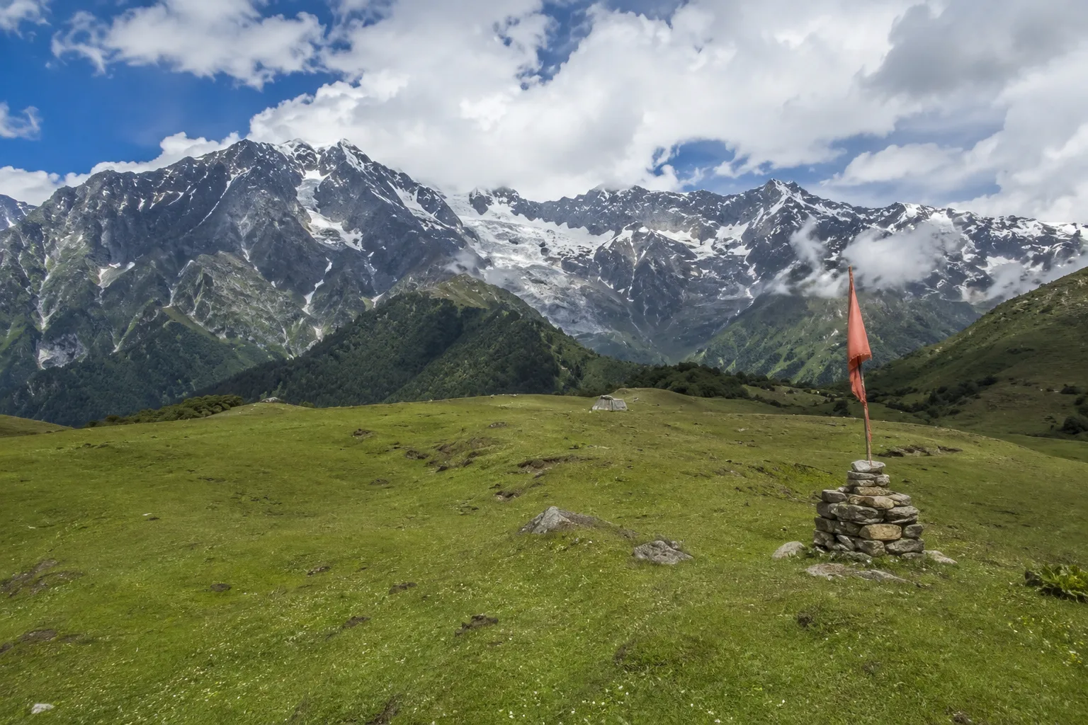
The Panch Kedar Circuit passes through some of Uttarakhand’s most beautiful alpine meadows, locally known as bugyals. These high-altitude grasslands offer expansive Himalayan views, seasonal wildflowers, and peaceful camping locations. Each bugyal has its own character, ranging from rolling green slopes to vast open meadows framed by snow-covered peaks, making them a major highlight of the trek.
Lyuti Bugyal: First High Camp Before Rudranath
Lyuti Bugyal sits at approximately 3,000 to 3,200 metres above sea level and serves as the primary campsite on Day 3 of the standard Mountainiax Panch Kedar itinerary. The trail to reach it begins in Sagar village and climbs steadily through oak, rhododendron, and buransh forest before the treeline breaks and the meadow opens ahead.
The bugyal itself is a wide, gently sloping grassland with unobstructed views toward the Nanda Devi range, Trishul, and the Hathi Parvat massif to the northeast. Camping here at night — with no artificial light for kilometres in any direction — makes this one of the best dark-sky locations on the entire circuit.
Lyuti Bugyal is the staging point for the Day 4 push to Rudranath Temple at 11,600 feet. Most trekking groups leave camp well before sunrise to reach the temple during darshan hours and return to Lyuti before mid-afternoon. The early morning light crossing the meadow on the descent back to camp is one of those moments that photographs never quite capture accurately.
The meadow hosts a notable population of Himalayan Monal (Lophophorus impejanus), Uttarakhand’s state bird, as well as Koklass pheasant and Snow partridge. Sightings are most common in the early morning hours before the camp stirs.
Buda Madmaheshwar Bugyal: The Ridge Above Madhyamaheshwar
The area around Madhyamaheshwar (11,450 ft) and the higher ridge toward Buda Madhyamaheshwar at roughly 13,000 feet contains some of the most extensive high-altitude meadows on the circuit. The main temple sits at the edge of a wide, bowl-shaped valley ringed by Kedarnath Peak, Chaukhamba, Neelkanth, and Nanda Ghunti.
The trail beyond the temple, continuing toward the upper ridge, passes through open meadows that are carpeted with Brahma Kamal in late July and August — just before and during the early monsoon fringe. The Brahma Kamal blooms at these elevations between late July and early September, making the post-monsoon window (September to early October) the best time to see the aftermath of the bloom while also enjoying cleared skies.
From the Buda Madhyamaheshwar ridge at around 13,000 feet, the panorama extends across the Kedarnath range. Experienced trekkers and guides sometimes describe this as the single finest viewpoint of the entire Panch Kedar circuit — above the treeline, above the temple, with nothing between the observer and the high Himalayan wall to the north.
This section of the trail also marks one of the Panch Kedar Solo Trek 2026 highlights for independent trekkers who add the upper ridge walk as a day extension from the Madhyamaheshwar camp. No technical climbing is required, but the altitude and open terrain demand solid fitness and good weather windows.
The Meadows Around Chopta: Gateway to Tungnath
Chopta, often called “Mini Switzerland of India,” sits at approximately 2,680 metres in the Kedarnath Wildlife Sanctuary. While technically a seasonal tourist settlement rather than a named bugyal, the surrounding terrain — including the open slopes above the treeline toward Tungnath and beyond to Chandrashila — is classic bugyal landscape.
The 3.5-kilometre trail from Chopta to Tungnath Temple (3,680 m) climbs through a gradient that transitions from dense rhododendron forest to open alpine grassland before the stone-paved path reaches the ancient temple complex. Above Tungnath, the final push to Chandrashila Peak at 4,000 metres crosses open meadow terrain with near-360-degree views of Kedarnath, Chaukhamba, Trishul, Nanda Devi, and Bandarpoonch.
The Chopta meadows are notable for their accessibility relative to altitude. Unlike Lyuti Bugyal or Buda Madhyamaheshwar, the open terrain near Tungnath can be reached without overnight camping, making it the most visited high meadow on the Panch Kedar circuit. This accessibility, however, also makes it the most ecologically stressed section. Plastic waste, unmanaged camping, and off-trail movement are documented issues that the Forest Department and Kedarnath Wildlife Sanctuary management have worked to address through entry restrictions and permit systems.
The Upper Slopes of Kedarnath Valley
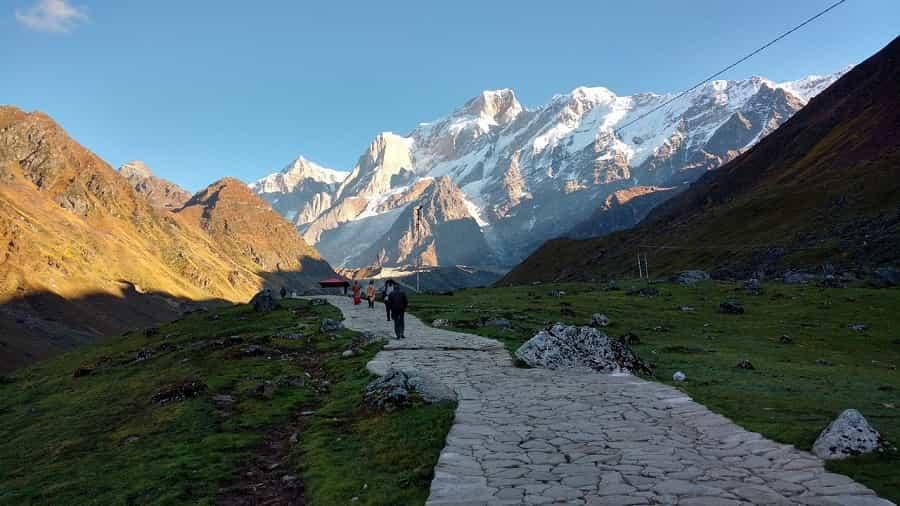
The trail from Gaurikund (1,982 m) to Kedarnath Temple (3,583 m) is the most walked pilgrimage route in the entire circuit. The lower sections pass through river gorge and forest, but above Rambara the landscape opens progressively. By the time the trail reaches the final kilometre before the temple, it crosses open, rocky meadow terrain with the Kedarnath dome and surrounding glaciated peaks forming the backdrop.
The wider Kedarnath valley — including the area between the temple and the Chorabari Glacier above — is high-altitude meadow habitat that also sits within the Wildlife Sanctuary boundary. Bharal (blue sheep), Himalayan Tahr, and occasionally Snow Leopard are recorded in the upper reaches of this valley, though wildlife sightings are understandably rare given the volume of pilgrims on the main trail.
Understanding the full ecological context of the Kedarnath valley — how it connects to the wider Panch Kedar ecosystem — enriches the experience of standing at the temple. The five sacred sites of the Panch Kedar circuit sit within and around one of the largest protected wildlife areas in Uttarakhand. For those familiar with The Five Forms of Shiva and their geographic distribution across the Garhwal Himalayas, the fact that these shrines occupy the most ecologically sensitive terrain in the region carries a meaning that goes beyond pilgrimage logistics.
Seasonal Character of the Bugyals: What to Expect Month by Month
The bugyals look completely different depending on when you visit. Understanding this seasonal rhythm helps trekkers choose the right window for the experience they want.
Pre-Monsoon: May to Mid-June
Snow is still present on the upper meadows in early May. As it recedes, the first flowering plants emerge — Primula species appear at snow edge almost immediately after melt, followed by anemones and early grasses. The meadows are a patchwork of white, gold, and green during this window. Temple opening days in May coincide with the first stage of snowmelt, so early-season trekkers see the bugyals in a transitional, dramatically lit state.
Temperatures at meadow elevation during May and early June range from around 5 to 15 degrees Celsius during the day, dropping to near or slightly below zero at night.
Monsoon: July to August
This is when the bugyals reach peak greenery. The combination of regular rainfall and warmer temperatures produces the densest, deepest grass of the year. Brahma Kamal blooms at higher elevations during this period. The meadows are at their most lush, but trails can be slippery and visibility intermittent due to cloud cover.
For trekkers willing to accept the weather limitations, the Panch Kedar Helicopter Yatra operates selectively during this season — primarily to Kedarnath — allowing pilgrims to visit the temple without navigating monsoon trail conditions. However, helicopter access does not cover the remote bugyals of Lyuti or Madhyamaheshwar, which remain foot-access only regardless of season.
Post-Monsoon: September to October
The post-monsoon window is considered the finest for bugyal photography and overall trekking experience. Skies clear after the monsoon withdraws, typically by mid-September. The meadows shift from deep green to golden-amber as grasses dry, with patches of late-blooming wildflowers still visible in sheltered hollows. Mountain views are sharpest during October.
This is the recommended season for most Mountainiax batches, precisely because the combination of clear sky, stable trail conditions, and the amber-toned meadow landscape is at its most rewarding.
Winter: November to April
Temples close in November (Kalpeshwar remains open year-round as the sole exception). Snow covers the upper bugyals fully by December and they remain inaccessible on foot until April or May. The Chopta area receives visitors even in winter for snow trekking, but the circuit bugyals at Lyuti and Madhyamaheshwar are deep under snowpack from December through March.
Wildlife of the Panch Kedar Bugyals
The bugyals support a layered food web that many trekkers walk through without recognising.
Herbivores: Himalayan Monal, Koklass Pheasant, Snow Partridge, Bharal (Blue Sheep), Himalayan Tahr, Musk Deer (in forest edges below the meadow line).
Predators: Himalayan Fox, Yellow-throated Marten, and at higher altitudes, Snow Leopard. Snow Leopard presence in the Kedarnath Wildlife Sanctuary has been documented through camera trap surveys, though direct sightings on trekking trails are extremely uncommon.
Insects and pollinators: The Brahma Kamal and other high-altitude flowers support specialised bumblebee species adapted to cold temperatures. Alpine butterfly species including the Himalayan Red Apollo are visible on sunny days in the meadows during summer and early autumn.
The ecological health of the bugyals depends directly on limiting grazing pressure, trail erosion, and waste. Responsible trekking — carrying waste out, staying on marked trails, avoiding campfires in open meadows — is not just ethical behaviour; it preserves the landscape that the trek depends on for its value.
Practical Notes for Trekkers
These practical trekking guidelines help protect fragile Himalayan ecosystems while improving your overall experience. Understanding responsible camping, photography timing, and altitude management ensures a safer, more enjoyable, and environmentally conscious journey through the stunning bugyals of Uttarakhand.
Leave No Trace in Bugyal Zones
Open fires are prohibited within the Kedarnath Wildlife Sanctuary, which covers most of the Rudranath and Madhyamaheshwar trail sections. Mountainiax groups use portable gas stoves for cooking at all campsites within sanctuary boundaries. All waste — including biodegradable food waste — is carried out rather than buried in the thin, fragile soil of high-meadow campsites.
Photography in the Bugyals
Early morning, roughly 30 to 60 minutes after sunrise, produces the best light in open meadow terrain. The low angle of light creates long shadows across the grass and illuminates wildflowers from the side. By mid-morning, flat overhead light flattens the meadow’s texture. The Lyuti Bugyal camp allows for early-morning shooting without any additional walking; the Brahma Kamal above Madhyamaheshwar requires a short uphill push.
Altitude Awareness at Meadow Camps
Lyuti Bugyal camp sits at approximately 3,000 to 3,200 metres. Most acclimatised trekkers handle this altitude comfortably by Day 3 given the gradual profile of the preceding days. Madhyamaheshwar camp at 3,497 metres is higher, and any significant physical exertion on arrival day should be avoided. The upper Buda Madhyamaheshwar ridge at around 4,000 metres should only be attempted by trekkers who feel completely symptom-free.
Frequently Asked Questions
1. What is a bugyal in the context of Uttarakhand trekking?
A bugyal is a high-altitude alpine meadow found in the Garhwal and Kumaon Himalayas, typically located between the upper treeline (around 3,000 to 3,500 metres) and the permanent snowline. They are characterised by open grassland, seasonal wildflower blooms, and panoramic mountain views.
2. Which is the best bugyal on the Panch Kedar circuit?
The meadows around Madhyamaheshwar and Buda Madhyamaheshwar are widely considered the most scenic, combining a high viewpoint ridge, Brahma Kamal habitat, and close-range views of the Kedarnath and Chaukhamba massifs. Lyuti Bugyal is the most remote and least visited, making it the most atmospheric for campers.
3. Can I visit the Panch Kedar bugyals without doing the full circuit?
The Chopta meadow and Tungnath trail can be visited independently in two to three days without committing to the full Panch Kedar circuit. Reaching Lyuti Bugyal or the upper Madhyamaheshwar meadows requires trekking into the circuit proper.
4. When does the Brahma Kamal bloom on the Panch Kedar route?
Brahma Kamal blooms primarily between late July and early September at elevations above 3,500 metres. The peak bloom period is typically the first two weeks of August around Madhyamaheshwar.
5. Is wildlife viewing possible on the Panch Kedar bugyal trail?
Yes, though sightings vary. Himalayan Monal is the most frequently spotted animal, particularly at Lyuti Bugyal in the early morning. Bharal are sometimes seen on rocky terrain above the Madhyamaheshwar valley. Snow Leopard presence is documented within the sanctuary but sightings on trekking trails are rare.
Summary
The bugyals of the Panch Kedar circuit are not backdrop. They are the breathing space between devotion and altitude — the places where the trail slows down, the sky opens up, and the mountains stop feeling like a destination and start feeling like a presence.
Most trekkers who complete the circuit remember two things with equal clarity: the darshan at each temple, and the mornings spent in open meadow with nothing ahead but grass, wind, and snow peaks. Those mornings at Lyuti, the ridge above Madhyamaheshwar, the golden slopes around Chopta — they stay with people long after the temple bells have faded.
The Panch Kedar route gives you five sacred shrines. The bugyals give you the silence between them.
With the Panch Kedar Yatra season approaching, it’s time to plan something truly extraordinary. From breathtaking Himalayan peaks to spiritually powerful temples hidden deep in remote valleys, this journey offers an experience that goes beyond a typical trek—it becomes a story you carry for life. To make your journey seamless and well-organised, choose the best trekking company in Uttarakhand for reliable trek packages, detailed itineraries, and hassle-free booking.
Visit this page for Trek Packages, Itinerary & Booking.